HereWeGo
April 6, 2026 • 6 min read
Route 66 is famous for its neon signs, roadside diners, and motels that seem to have been frozen in time since the 1950s. This iconic highway was built for road trips, featuring long stretches that wind through small towns dotted with gas stations, eateries serving homemade pies, and blinking hotel
```html
Highlights of Route 66
Route 66 is famous for its neon signs, roadside diners, and motels that seem to have been frozen in time since the 1950s. This iconic highway was built for road trips, featuring long stretches that wind through small towns dotted with gas stations, eateries serving homemade pies, and blinking hotel signs beckoning drivers to stop.
However, this "Mother Road" offers much more than just charming roadside attractions — it boasts some truly grand sights. Stretching over 2,500 miles, it runs close to vast protected lands. From the Midwest to the Pacific, it traverses caves, canyons, lava fields, mountains, and deserts, many of which have now become national parks, state parks, or national forests. Many of these parks are just a short detour from the highway.
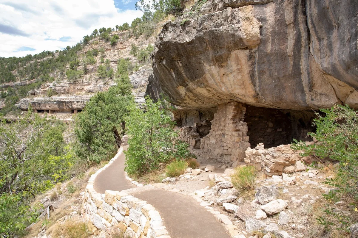
Walnut Canyon National Monument (Arizona)
Distance from Route 66: 5 miles
Entrance Fee: $25 per vehicle (cash not accepted)
Address: 3 Walnut Canyon Road, Flagstaff, Arizona 86004
Just outside of Flagstaff, Walnut Canyon preserves numerous caves carved from natural limestone, which were home to the Sinagua people from around 1100 to 1250. These dwellings were built right into the canyon walls, and many are still visible today. The main walking trail is the Island Trail, a 1-mile loop that descends about 185 feet via steep stairs.
Along the way, you’ll pass around 25 cliff-side rooms, some just a few feet from the trail. It’s a short hike, but the steepness and elevation gain can make it more challenging than you might expect. Plan to spend about 1-2 hours walking and bring everything you need, as the nearest water source is at the Island Trail visitor center, and there are no refill stations along the trail. The trail closes daily at 4 PM, so plan accordingly.
Indiana Dunes National and State Parks (Indiana)
Distance from Route 66: approximately 30 miles
Entrance Fee: $25 per vehicle
Address: 1215 N State Road 49, Porter, IN 46304
Indiana Dunes National Park sits along the southern shore of Lake Michigan, protecting about 15 miles of coastline with a mix of beaches, wetlands, forests, and some of the tallest dunes in the Midwest. Here, you’ll find a variety of short trails that traverse completely different landscapes within a small area. Located just east of Chicago, it’s worth a visit before you kick off your Route 66 adventure.
The most popular stop is the Dune Succession Trail at West Beach, where a short, steep path leads to stunning views of Lake Michigan and the surrounding dunes. Other options include Mount Baldy (one of the tallest dunes in the park) and flatter coastal trails if you’re looking for something easier. In summer, the beach is open for swimming, making it one of the rare stops on Route 66 where you can actually take a dip.
✈️ Tìm chuyến bay giá tốt
Đặt vé ngay với giá ưu đãi từ các hãng hàng không
Lava River Cave (Arizona)
Distance from Route 66: 14 miles
Entrance Fee: Free
Address: Forest Road 171B, Flagstaff, AZ (no official address)
Lava River Cave is a lava tube located in the Coconino National Forest in northern Arizona. It formed about 700,000 years ago when lava solidified on the outside while the still-flowing lava continued to drain away, resulting in a nearly three-quarter-mile long underground tunnel, making it the longest known lava tube in the state. This site is open to the public, and anyone can enter without a guide or reservation (though some safety precautions are necessary).
Unlike developed cave parks, there are no lights or railings here. Parking is relatively close to the cave, but the uneven terrain requires some climbing. The cave's ceiling height varies significantly, so watch your head and consider bringing a helmet, as you may need to duck in some areas. The cave is typically accessible only with snow shoes in winter and maintains a chilly temperature ranging from 35 to 45 degrees F year-round, so it feels a bit like stepping into a refrigerator.
Petroglyph National Monument (New Mexico)
Distance from Route 66: 8 miles
Entrance Fee: Free
Address: GPS Lat: 35.139 GPS Long: -106.711, Albuquerque, NM 87120
The Petroglyph National Monument is one of the most unique historical parks alongside Route 66, showcasing signs of human creativity and culture that date back thousands of years. It features over 20,000 images carved into volcanic rock by indigenous peoples and early Spanish settlers, nearly all of which can be seen through a few short walks.
From the visitor center, you’ll need to drive a few minutes to one of three canyon trail areas: Boca Negra Canyon, Rinconada Canyon, or Piedras Marcadas Canyon. The carvings at Boca Negra Canyon are the easiest to see, requiring just a quick 15-minute walk. Rinconada Canyon offers a 2.5-mile loop where you can see art on the canyon walls while walking, and the 1.5-mile trail at Piedras Marcadas Canyon is the least developed but has the most carvings.
Mojave National Preserve (California)
Distance from Route 66: approximately 20 miles
Entrance Fee: Free
Address: 90942 Kelso Cima Rd, Essex, CA 92332
As Route 66 enters California, it traverses the edge of one of the largest protected desert areas in the U.S.: Mojave National Preserve. This area protects 1.6 million acres of land with sand dunes, lava tubes, volcanic craters, and dense Joshua trees. It is quiet, dramatic, and often desolate, with long stretches where you might not see another soul for miles.
Unsurprisingly, stargazing here is phenomenal. The Kelso Dunes Trail is a standout hike within the park. It's about a three-mile round trip but quite challenging, as you’ll be walking on sand, with each step sinking a bit. But once you reach the summit, you’ll be rewarded with a 360-degree vista overlooking the entire 45 square miles of dunes. Sometimes, you can even hear the unusual rumbling sound made by dry sand moving and vibrating. Under the right conditions, the dunes can "sing" — a low, rumbling sound produced when dry sand shifts beneath your feet as you walk or slide down.
Onondaga Cave State Park (Missouri)
Distance from Route 66: 7 miles
Entrance Fee: Free, guided tours are available for a fee
Address: 7556 Highway H, Leasburg, MO 65535
Onondaga Cave State Park is located just south of Route 66 in central Missouri and is one of the easiest places along the route to join a guided cave tour. The park protects two main caves: Cathedral Cave and Onondaga Cave; the latter is a National Natural Landmark. Tours depart from the visitor center and follow paved walkways, with lighting inside the caves, making it accessible for most beginner hikers.
```HereWeGo
HereWeGo is a leading online flight booking platform in Vietnam, providing accurate and up-to-date travel information. We are committed to delivering wonderful travel experiences with the best prices on the market.